

Reading a neighbourhood
| Street pattern | Grids usually predate the motor car. Curving roads and cul-de-sacs are later, and were designed around it. |
|---|---|
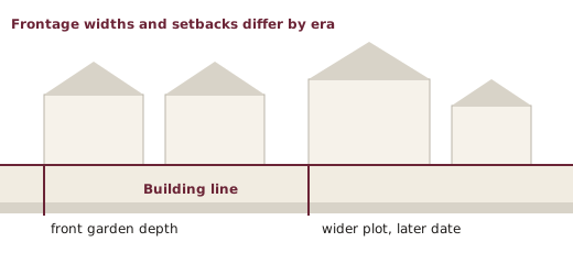
| Building line | How far homes sit back from the road. Consistent deep setbacks indicate planned development rather than gradual infill. |
| Frontage width | Narrow frontages mean land was expensive or plots were subdivided. Wide frontages mean the opposite. |
| Plot depth | Long rear plots often survive from earlier field boundaries and are a common source of later infill building. |
| Materials | Local stone and brick indicate building before cheap transport. Uniform imported materials indicate after it. |
| Boundaries | Original walls, railings and hedges mark the first phase. Replaced boundaries mark later subdivision or road widening. |
A residential street is a document. It records when it was built, what transport existed, how land was owned before it was developed, and what the rules were at the time. Reading it takes no specialist training, only the habit of asking why each thing is the shape it is.
Why districts formed where they did
Before mechanised transport, housing had to be within walking distance of work, so towns were dense and mixed. Everything within that walking radius was built tightly, with narrow frontages, because land close in was expensive and the plots were subdivided as far as they would go.
Rail and tram changed the radius, and the first suburbs appeared along the lines rather than in rings. Their signature is a station and a short parade of shops, with terraced or semi-detached housing spreading outward from it and thinning with distance. Where a district's street pattern converges on a station or a former tram route, that is usually why it exists.
The motor car changed it again, and much more thoroughly. Once travel was no longer tied to a fixed line, development could fill the spaces between the corridors. This is the era of long arterial ribbons, and then of estates laid out as loops and cul-de-sacs, in which through traffic is deliberately designed out and the street stops being a route to anywhere.
Reading the plot
The most durable evidence is not the buildings but the land divisions beneath them. Field boundaries, old lanes and estate limits survive long after everything on them has been rebuilt, which is why an unexpectedly long rear garden, a kink in an otherwise straight road, or a boundary that ignores the modern grid usually marks something older.
Plot depth is also the main determinant of what can happen next. Deep plots invite infill: a new house at the bottom of a garden, a lane driven through to reach it, and a change in the street's character that follows the ownership pattern rather than the architecture.
Reading the street
- A consistent building line and repeated house type indicate a single developer working at once. Varied lines and types indicate a street filled in over decades.
- Original front boundary treatments that survive along most of a street suggest low pressure for off-street parking; their loss suggests the opposite.
- Corner buildings that differ in type, often shops or a former public house, mark where footfall once concentrated.
- Wide grass verges and generous carriageways are a planning signature of a particular period of estate design, not an accident of space.
Why character is not the same as quality
Character describes what a place is; it does not rank it. A tightly built terraced street and a low-density estate are answers to different problems, built under different constraints, and each does some things the other cannot. What is worth knowing is which constraints produced the place you are standing in, because those constraints usually still shape how it works: where parking goes, how noise travels, where the sun falls, and where the next building is likely to appear.